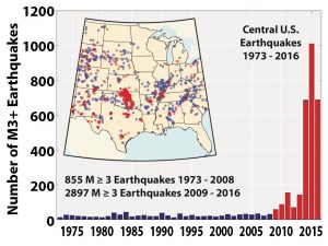
 The frequency and intensity of earthquakes has increased dramatically in the United States. This is attributed to disposal of liquid waste from fracking and tertiary oil recovery activities, especially in the plain states. Kansas experienced a spate of quakes in fall 2014, and TBirdie Consulting was tasked with addressing the risk of seismicity in order to address EPA’s concern regarding injection of anthropogenic carbon dioxide in southern Kansas. We successfully developed a methodology to address the risk of seismicity within six months and our findings were shared with the scientific community at the Geological Society of America conference in spring 2015. Since then, the company has continued to improve methodologies for mitigating the risk of induced seismicity, which can assist our clients in developing operational strategies for liquid waste disposal in saline aquifers to prevent earthquakes. The following information is needed to address seismic risk at a site:
- Fault: length, orientation, and frictional/cohesive strength
- Stress Field: orientation and magnitude of the principal stresses
- Pore Pressures: pre and post injection reservoir pressures, especially along faults
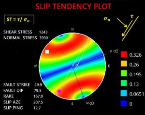 We utilize the various geophysical logs and injection tests to determine the stress field at a site. Seismic surveys can be conducted to identify faults in addition to utilizing motion sensors, such as seismometer and geophone, to delineate fault zones. Advanced three dimensional stress analysis is conducted to calculate the slip potential of suspected faults so as to establish safe injection rates and volumes to prevent earthquakes. Scaling relationship between faults size and earthquakes are also utilized to estimate the magnitude of earthquake under the worst-case fault slippage scenario in order to characterize the ultimate seismic risk.
 simulating the movement and chemical alteration of contaminants in the subsurface. These models can account for complex biophysicochemical process including advection, dispersion, diffusion, sorption/desorption, decay, and chemical-biological and nuclear reactions within deterministic and probabilistic frameworks.
 Our expertise in systems optimization allows for integration of our advanced numerical models with efficient global optimization schemes, which facilitates evaluating remedial investigation schemes and developing effective remediation systems. At locations with adequate operational data, we can construct hydrologic neural network models to accurately reflect the site hydrodynamics. The benefit of our coupled simulation-optimization models include more cost-effective expenditure of cleanup funds, lower energy consumption, improved decision-making, and the ability to reliably identify Potentially Responsible Parties.
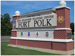 systems at over 20,000 Department of Defense family housing units and over 250 commercial and public facilities for a total project value of over $65 million.
 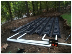 He was the Engineer of Record for the design of the largest GCHP systems in the world at Fort Polk, Louisiana in 1994, which consisted of individual ground-coupled heat pumps installed at over 4,000 housing units at the base. This project was extensively monitored by Oak Ridge National Laboratories and formed the basis for the (Geothermal) Super Energy Savings Performance Contracts (Super-ESPC) program established by the U.S. Department of Energy. This project saved over 26 million killowatt-hours per year, or 33% of all electrical energy used in family housing at Fort Polk.
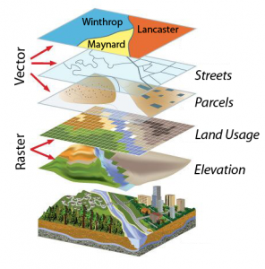
 TBirdie Consulting specializes in the use of geospatial information technologies (GIS) to optimize data for applications in the environmental, engineering, and energy industries. We create custom GIS applications to meet specific needs of users which greatly increase productivity by minimizing repetitive tasks and automating execution of complex tasks. We achieve this through our expertise in ArcObjects programming. ArcObjects is the technologic framework on which ArcGIS is built. It consists of a collection of software components with GIS functionality and programmable interfaces. These geospatial apps integrate backend infrastructure technologies, content management, and modern visualization techniques resulting in a relevant presentation of large and complex data without overwhelming the user and assisting in decision-making. Our team is also experienced in developing GIS solutions for regulatory compliance related to federal air emissions, hazardous waste disposal, and groundwater management.